Confusing intersection of Milwaukee-Wood-Wolcott to be redesigned and reconstructed in Spring 2013 (was September)

Update September 7, 2012: From the Wicker Park-Bucktown SSA, we get news that this project has been pushed back to spring 2013. It seems IDOT is responsible for this delay. 

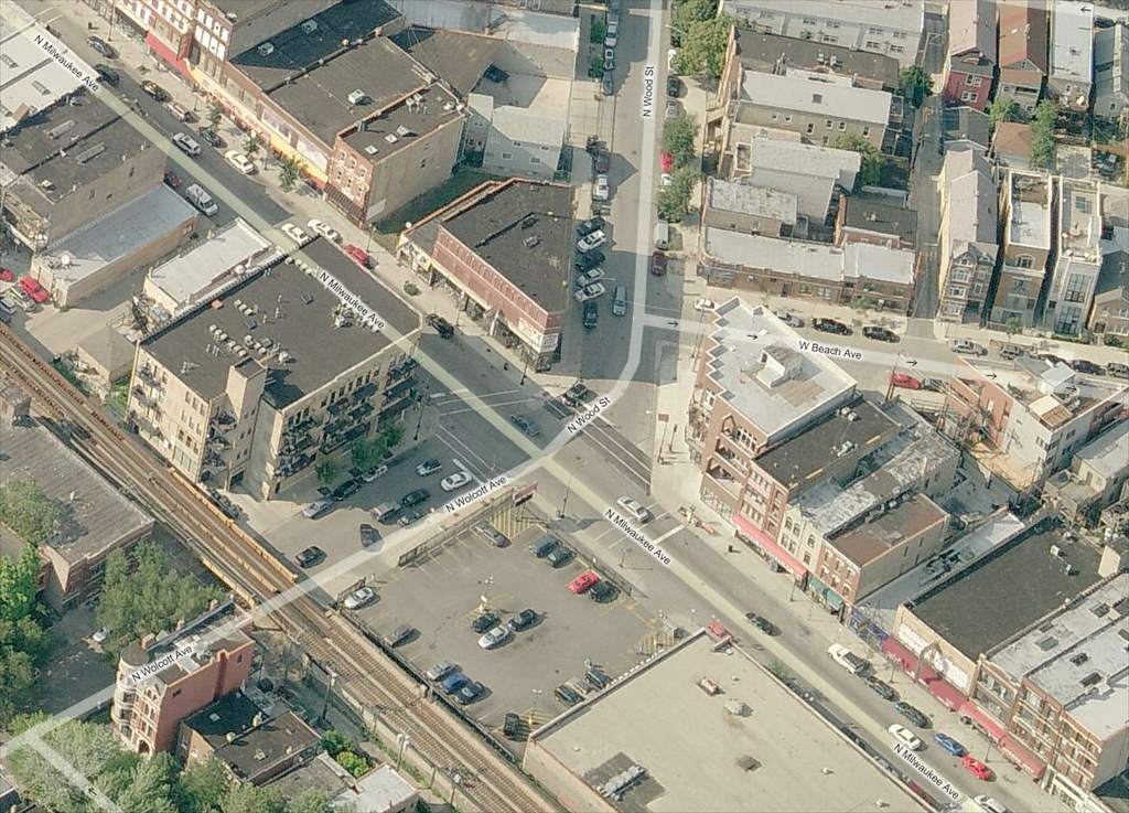
The skewed intersection of Milwaukee Avenue, Wood Street, and Wolcott Avenue in Wicker Park will be redesigned and reconstructed this year as part of a project to upgrade the signals. The original project only called for upgrading the traffic signals, which are decades old and very hard to see. Their timing is also awkward, providing no “all red” phase between the red phase of one direction and the following green phase of the cross direction. Construction should begin in September, according to the 1st Ward office.

Confusion is compounded with the addition of a rare slip lane on Wood Street at Milwaukee Avenue, which is created by a small island of concrete that only holds a light signal pole for southbound traffic. More often, islands are used to help protect pedestrians from traffic.

Bird's eye view of Milwaukee Wood Wolcott

View the intersection in a larger map on Bing Maps.

Continue reading Confusing intersection of Milwaukee-Wood-Wolcott to be redesigned and reconstructed in Spring 2013 (was September)

Exposing people to “strange” new pavement markings

[flickr]photo:6795855942[/flickr]

Mark, a former Chicagoan, now Bostonian, posted this photo of a flyer he received in his “motor vehicle excise tax” bill (think of it like the annual city sticker, but much more costly). It describes and displays the new kinds of pavement markings that are showing up around Boston. It says, “New pavement markings for cyclists are cropping up around the city. Here’s what they mean for drivers.”

The two-sided flyer uses graphics from the NACTO Urban Bikeway Design Guide to show bike lanes, shared lanes, bike boxes, and cycle tracks. The opposite side thanks Bostonians for making Boston America’s safest city for walking and cycling. I didn’t know it was – I’d like to know more about this and which data source or metric they’re using.

A pamphlet in property tax bills and city sticker applications could be the start of a wider campaign to bring awareness to different street designs (which were put in place to make one or more transportation modes safer than before). The best bet for sustainable awareness raising is to start moving towards mobility education in schools and at the DMV.

Continue reading Exposing people to “strange” new pavement markings