Highlights from the Chicago Pedestrian Plan

[flickr]photo:6965968141[/flickr]

A Metra train crosses Canal Street, while a person waits to cross the tracks. Photo taken by ryanbytes. 

Our article on Monday discussed some highlights and shortcomings in the Pedestrian Plan, released last week. This post spotlights more of the smart objectives and features in the plan. It additionally features ideas that have been on the books for a while, with little progress made. It helps to have the Chicago Pedestrian Plan open while you read this post; the plan isn’t available as a website.

The previous post listed improving expressway entrances (mainly near train stations, p.73-75), six-way intersections (p.69-71), and developing standards for the pedestrian experience within parking lots (p.76). Each tool or strategy below summarizes the aim of each in “What it says” but isn’t a complete representation of the milestones or action items for that tool or strategy.

Mobility education, 53 Continue reading Highlights from the Chicago Pedestrian Plan

Strategies in the Pedestrian Plan: Skinny streets

[flickr]photo:6864053991[/flickr]

This rough drawing shows what could be done with the extra space if Haddon Avenue was narrowed and remained one-way. It doesn’t show what the street would look like if it were two-way. The drawing shows two scenarios with features that use the land reclaimed from asphalt: the first shows a cycle track. A speed limit sign says “neighborhood speed limit” (a number is left off so residents decide what speed is appropriate for their street). The second scenario has a rain garden in the land reclaimed from asphalt, to help with stormwater management. Both scenarios have permeable pavers in the parking lanes. 

The first-ever Chicago Pedestrian Plan will be introducing a lot of new concepts and ideas to Chicagoans (and even this transportation planner) about how to make the pedestrian experience safer, more comfortable, as well as more enjoyable. This post will be one of the occasional articles on strategies in the Pedestrian Plan.

Tool: Skinny streets, page 29

What it says: “After the severe winters of 1978 and 1979, many of Chicago’s streets were converted from two-way to one-way to improve mobility during the winter and to allow plows to go through. However, two-way streets have many advantages over one-way streets. These ‘skinny streets’ reduce vehicle speeds and can also increase connectivity for all users by providing more ways to traverse the city’s grid. Skinny streets should be considered on all one-way streets that are wider than 30 feet.”

Download the Chicago Pedestrian Plan in .pdf format: 15 MB or 100 MB. No web version available.

Continue reading Strategies in the Pedestrian Plan: Skinny streets

Chicago’s first pedestrian plan includes great ideas, lacks some information

[flickr]photo:7966249572[/flickr]

A press conference was held last Thursday at the southeast corner of Dearborn Street and Madison Street to announce the city’s first pedestrian plan. Present were commissioners of transportation and public health, Gabe Klein, and Bechara Choucair, respectively, Metropolitan Planning Council vice president Peter Skosey, and various CDOT staff.

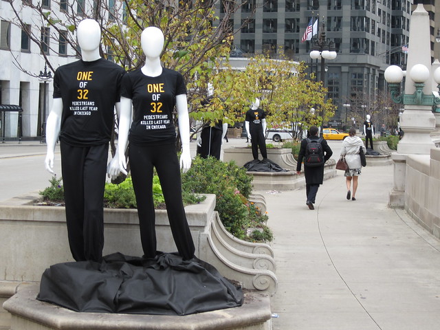
After 20 minutes of speeches from Klein, Choucair, Skosey, and Active Transportation Alliance director Ron Burke, CDOT pedestrian program coordinator Suzanne Carlson and Klein applied a diamond shaped decal to a sidewalk corner across Madison Street. The bright yellow “sticker on the street” says, “Be Alert. Be Safe. We’re all pedestrians.” It’s part of the Pedestrian Safety Campaign launched last year that also included 32 mannequins scattered around Wacker Drive and then to other sites, as well as orange flags at certain crosswalks, and a somewhat grotesque ad campaign on trash bins and buses.

The Pedestrian Plan has its merits and faults. The document is nicely designed, easy to read, informative (it does a great job introducing people to “pedestrian safety tools” that are mentioned later in the plan), but still speaks to the car-centric profession of traffic (transportation) engineering exhibited in Chicago. Continue reading Chicago’s first pedestrian plan includes great ideas, lacks some information

Chicago transportation to move very far forward with two-year plan

[flickr]photo:6854766271[/flickr]

Looking down Madison Street. Photo by Daniel Butler. 

A new plan for the Chicago Department of Transportation was released today and Grid Chicago got to talk to commissioner Gabe Klein this morning about the Chicago Forward CDOT Action Agenda’s development, strategies, and goals.

I started reading the 100 page plan last night to prepare for today’s interview. After the obligatory messages from Mayor Emanuel and Commissioner Klein (as well as photos of a Brown Line train and the bean), there’s a timeline and a short historical narrative. This plan gives a new mission statement for the department and is the first time a vision statement has been adopted by the agency (which the timeline tells was created in 1992 after a reorganization of the Department of Public Works). The Action Agenda is important to ensure our transportation system (as envious or dubious as you see it) changes in good, appropriate ways. Not only do we know how CDOT will get us there, Chicagoans will be able document change and compare our status in 2014 to where we started in 2012. Continue reading Chicago transportation to move very far forward with two-year plan

Community plans for life in Chicago and the region

[flickr]photo:6433633069[/flickr]

Chicago and Chicagoland communities have officially adopted plans to provide more transportation opportunities, reduce obesity, and increase access to open space; they list how bicycling is or can be a strategy to achieve a healthy city, a bike-friendly city, and a green city. Here’s a sampling of those agendas:

I’d like there to be a Chicago-wide comprehensive plan that addresses goals and strategies outside the scope of these plans but still includes these efforts. A plan that concentrates on transit, congestion, on crime and safety, housing, education and the economy. Its purpose would be the same as the other plans, to outline targets and intentions and measures of achievement, but also to ensure that no plan and the people implementing the plan were working at cross-purposes. For example, if there’s a plan to increase the number of people who bike and the number of people who take transit, are the implementers of each plan working together to ensure a citizen’s smooth transition from one mode to the other in a single trip? Another example: If a goal is to increase the number of people who take transit, are implementers making buses run more on time by reducing single occupancy vehicle congestion and giving buses priorities at signals, two strategies that would speed up bus movement and make it easier to create a schedule they could stick to?

A plan like this that comes to mind is PlaNYC. From the article on Wikipedia about PlaNYC:

PlaNYC is an effort released by New York City Mayor Michael Bloomberg in 2007 to prepare the city for one million more residents, strengthen the economy, combat climate change, and enhance the quality of life for all New Yorkers. The Plan brought together over 25 City agencies to work toward the vision of a greener, greater New York. PlaNYC specifically targets ten areas of interest: Housing and Neighborhoods; Parks and Public Spaces; Brownfields; Waterways; Water Supply; Transportation; Energy; Air Quality; Solid Waste; Climate Change.

Updated 21:36 to add more plans, thanks to the commenters. 
Mannequins remind drivers and pedestrians to travel safely

IMG_0892

32 ghostly-white figures line the north side of Wacker between Wabash and Clark, but they’re not Halloween decorations. These mannequins, male and female, wear black t-shirts reading “One of 32 pedestrians killed last year in Chicago.” On the back the shirts read “It’s up to you. Be Alert. Be Safe. We’re all pedestrians.” These dummies are part of the city’s new shock-and-awe campaign to raise awareness of pedestrian safety issues and reduce crashes. The Chicago Department of Transportation (CDOT) is spearheading the initiative with the help of the Chicago Police Department, funded by a grant of almost $550,000 from the National Highway Traffic Safety Administration (NHTSA).

Continue reading Mannequins remind drivers and pedestrians to travel safely