Update September 7, 2012: From the Wicker Park-Bucktown SSA, we get news that this project has been pushed back to spring 2013. It seems IDOT is responsible for this delay.
The skewed intersection of Milwaukee Avenue, Wood Street, and Wolcott Avenue in Wicker Park will be redesigned and reconstructed this year as part of a project to upgrade the signals. The original project only called for upgrading the traffic signals, which are decades old and very hard to see. Their timing is also awkward, providing no “all red” phase between the red phase of one direction and the following green phase of the cross direction. Construction should begin in September, according to the 1st Ward office.
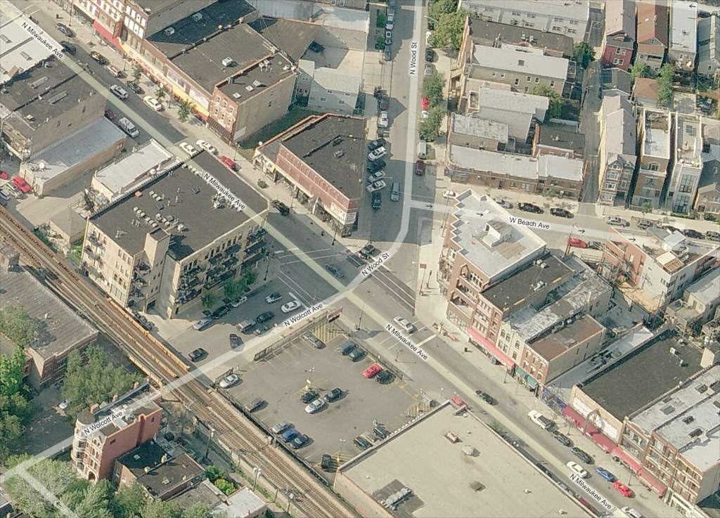
Confusion is compounded with the addition of a rare slip lane on Wood Street at Milwaukee Avenue, which is created by a small island of concrete that only holds a light signal pole for southbound traffic. More often, islands are used to help protect pedestrians from traffic.
View the intersection in a larger map on Bing Maps.
On Friday, February 17, 2012, I was cycling to a friend’s house on Friday and while stopped at the Milwaukee-Wood-Wolcott intersection, I spotted a friend, Code for America fellow Ben Sheldon, and his partner. Since I was on a bicycle, I stepped onto the sidewalk to have a quick chat. Somehow we started talking about the intersection. Unsolicited, Ben and Angelina told me about their observations of the intersection. They were spot on:
While walking down Milwaukee Avenue, the intersection and fast-moving cross-traffic we half-stepped out into were unexpected. There was also a parked car that caused us not to see incoming cross-traffic. There is very little to indicate that it’s a signaled intersection instead of what I expected it to be – a two-way stop – when I stepped into the road. There aren’t walk signals and the traffic lights themselves, not hanging over the intersection, are easy to miss from the curbs.
A major aspect of safe road design is homogeneity and using standards. But standards change, as do our expectations. Many intersections, like this one, are “left behind” and fail to be updated. Perhaps showing the difficult in seeing the traffic signals as they are now, I captured two drivers running a red light on Milwaukee Avenue a few seconds before it turned green.
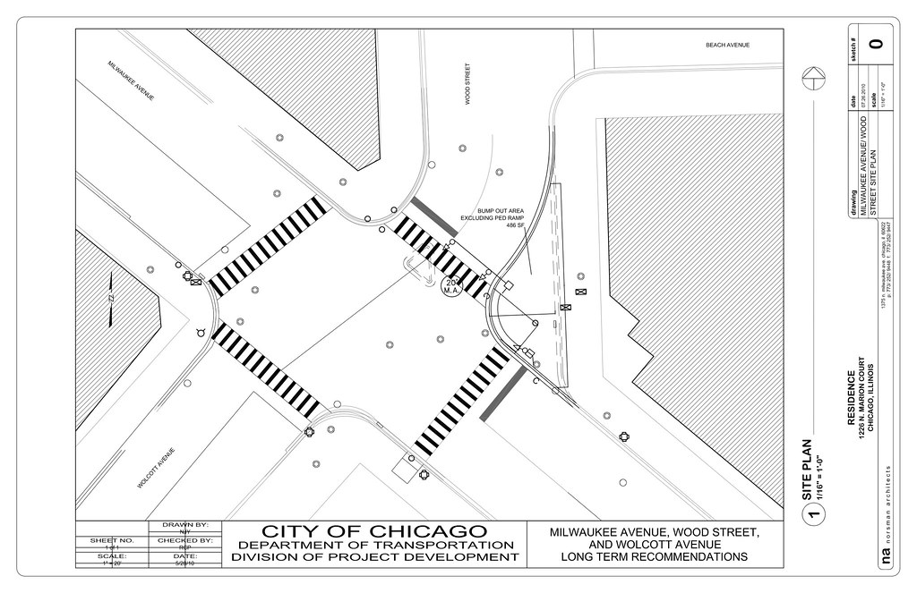
This image shows the Chicago Department of Transportation’s plans for the intersection.
In addition to upgrading the light signals here to modern standards (with walk signals to boot), the Wicker Park-Bucktown Special Service Area (see note 1) and 1st Ward Alderman Moreno’s office are splitting the cost of engineering and construction to build a curb extension that aligns Wolcott Avenue with Wood Street. Without the investments from these organizations, the soft radius at the east corner of Wood Street and Milwaukee Avenue would have remained. Included in this curb extension will be an area to create a bioswale. There will be small curb cuts in the gutter to allow storm water to flow into the bioswale and be filtered naturally by landscaped vegetation there.
Additional changes
The curb ramps from the street to the sidewalk will also be reconstructed to meet Americans with Disability Act (ADA) standards. The Illinois Department of Transportation (IDOT) is paying for this along with the signal upgrades. Crosswalks will be restriped in the international style (also known as zebra or ladder), and a new marked crosswalk will be installed on the south side of the intersection. There already exists an unmarked crosswalk here. From the Bing Maps “bird’s eye view” image above, you’ll see a marked crosswalk, but in the view below, it’s missing. The street was repaved in 2005 and it appears that it wasn’t reinstalled.
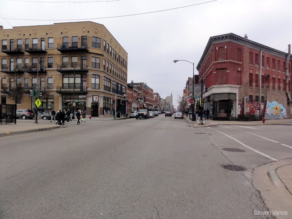
No crosswalk on the south side of the intersection across Milwaukee, but there was one prior to resurfacing in 2005.
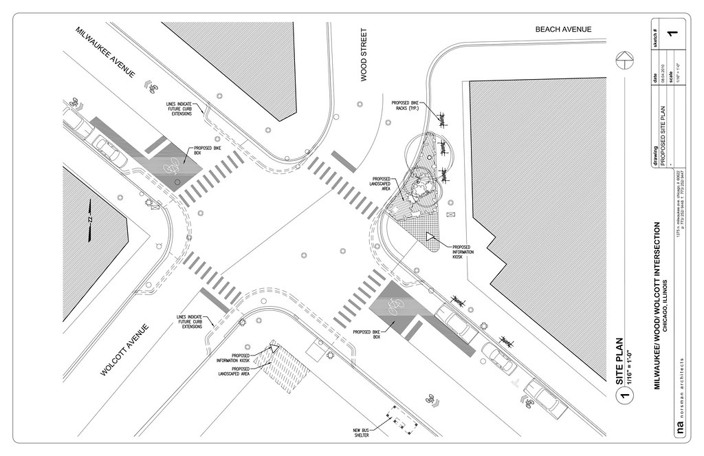
Image shows potential additions, but not coming in the 2012 intersection reconstruction. View this ideal plan drawing large.
Local architect Brent Norsman, an SSA commissioner and transportation committee member, imagines more changes down the road. He created this drawing shown an ideal intersection, with curb extensions at all corners (to shorten the walk distance), bike boxes on Milwaukee Avenue, more landscaping, a new bus shelter near Walgreens, bike racks designed by a local artist, and information kiosks. I called Norsman to get a better understanding of how and why he created this design.
We entered a competition to make Red Hook, Brooklyn, the most bike friendly neighborhood in the world. What would that look like? We did a lot of research on the latest ideas from planners around the world.
But why a competition about bicycling?
I have always hired people who bike and the office has always been on Milwaukee Avenue and I’ve become attached to the street. I’ve watched ridership go up.
The view from the Norsman Architects office.
How did your entry in the competition lead to proposing a new intersection design for Milwaukee, Wood, and Wolcott?
Fresh off the competition we wanted to imagine better a better Milwaukee Avenue, so we hyper-analyzed the corner closest to our office [Milwaukee, Wood, Wolcott]. We presented the drawings [third image] to then-Alderman Manny Flores. He advised that we talk to the SSA. Once part of the SSA, we learned of plans to upgrade the intersection’s light signals only. I pulled out the drawings and showed them to Janet Attarian at CDOT; she has a good sense of realism on what they can accomplish. She was also aware of the kinds of progressive ideas in my drawings. She brought the bioswale idea to us.
Cost of the ideas in Norsman’s drawings were a main barrier, thus leading to contributions of $25,000 each from the 1st ward office and the SSA.
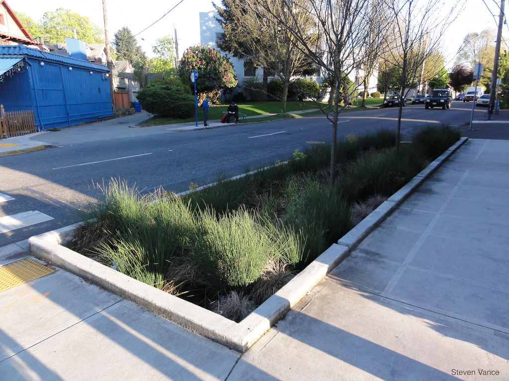
A bioswale in Portland, Oregon. Notice the little slits in the curb – this allows storm water runoff to enter the landscaped area where a careful selection of plants and the right base quickly absorbs water, faster than a grass lawn.
This Street View image shows the “traffic island” at Wood Street and Milwaukee Avenue. View in larger window, or see the satellite view.
Crash stats for this location
When cleaned crash data (see note 2) for 2012 comes around in August 2013, we’ll be able to evaluate this intersection again to see if the infrastructure investments made an impact on the crash rate. Contrary to what I predicted, there were actually 10 bicycle-automobile crashes and 1 pedestrian-automobile crash between 2005-2010, injuring 11 people, none of them occupants of automobiles. I thought the pedestrian crash figure would be higher.
In addition to the 11 crashes between automobile drivers and those walking and cycling, there were 73 crashes between automobiles in the same period (and within 200 feet). The majority of these were “property damage” only, meaning there was no evidence of injury at the time. 200 people were involved in these crashes; 20 people were injured.
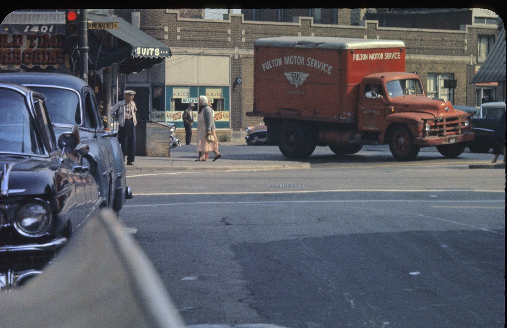
The intersection’s layout hasn’t been changed since at least 1959. In this photo you can see the signal pole in the tiny island along with the soft radius at the east side of Wood Street and Milwaukee Avenue. Photo by masMiguel.
Notes
1. Disclaimer: I am a member of the transportation committee of the Wicker Park-Bucktown Special Service Area, SSA 33.
2. The data I receive comes from the Illinois Department of Transportation which cleans up the Chicago Police Department’s sloppy inputs. Jon Hilkevitch at the Chicago Tribune reported yesterday about how the police’s crash reports have many errors and that the Chicago Department of Transportation receives these “as they happen” (instead of waiting until August of the following year like myself).
View all my photos of this intersection.
Great article–agreed these improvements are badly needed, as this intersection is nothing short of treacherous. I have nearly run red lights multiple times driving through it, and I never really feel safe crossing it on foot or bicycle. Good to see this happening
Thanks for the article. I live close to this intersection, and the only reason I navigate it easily is because I know it well.
Great article! Real informative with all of the data, quotes, pics, etc. Looking forward to the construction.
it all fell apart when Big Tony’s pizza was demolished. : )
Too bad that WPB and Ald. Moreno couldn’t spring for the “ideal” treatment. I know funds are limited, but it seems like it would be much cheaper to do the full upgrade now vs. building it piecemeal.
I agree that the light needs an upgrade, as it’s very easy for people who don’t know it’s there to overlook. Additionally, walk signals and striping needs to be improved. But this is a situation where I don’t see the rest of the problem. Aside from the signaling, I don’t think this intersection is all that confusing. Your crash data seems to support this, which is why you don’t see a lot of pedestrian crashes. The bulk of the problems in this location stems from aspects of the area not really related to the intersection itself. Heading outbound, this is where the Wicker Park backup starts, and sometimes that traffic backs into the intersection, blocking it and causing a scrambling of cars into unexpected spots, usually the bike lane. You have a high number of cars making random u-turns in this area. You have a lot of delivery traffic at various locations blocking lanes or parts of lanes. And you have traffic entering and exiting the Walgreens parking lot. (I personally have had a lot of close calls from this.) I would suspect most of the car-bike crashes owe to one or more of these factors more than they do the structure of the intersection itself.
In short: Everything beyond the lights is a pretty upgrade, but I don’t see it serving much purpose beyond the aesthetic.
Nice, very informative.
That corner is a nightmare–and while the official stats of pedestrian and bike accidents might be low, I guarantee there have been many many more near-misses or unreported accidents. And the Trib had a story the other day about how the CPD’s traffic incident reporting method is inaccurate compared to the State of Illinois’s. Great to see so much creative thinking going into this redesign.
I agree that the stats may be low. The State of Illinois data, which is the only crash dataset I’ve used for Grid Chicago, will exclude crash reports where there was not $1,500 in property damage, or there was no injury. So that’s one reason why my stats may be low. And there may be unreported crashes.
I saw the same story in the Trib about CPD’s bad crash reporting methods. Have you seen how complicated the traffic crash report is? Mine was made in error, but IDOT corrected it (I checked the dataset for it). Here’s my crash report: http://www.flickr.com/photos/jamesbondsv/5665943713/
I live right around the corner from this intersection and it’s truly a nightmare to navigate. No cross walk, no walk signals, difficult to see traffic lights, and confusing street layout all need improving. Cars that are familiar with it fly through, but unfamiliar drivers hesitate and are understandably confused. It’s really dangerous. This improvement will be a boon to safety and local business, for sure.
This REALLY needs to be done, as soon as possible. I wait for the bus heading downtown in the morning for just a few minutes every day. I’ll bet I see 3 cars go right through that red light a week. It’s very dangerous with the old street lights – they’re hard to see. With all the bikes, cell phones, people crossing, bus traffic, kids in strollers using that intersection it’s a mess. I can only hope no one gets hurt before it gets fixed. The new plan looks good.
Oh please !! I’ve lived in that neighborhood for 28yrs..It’s you yuppies that come from where ever,always complaining about something. From what I see it’s the people on bikes that act like they own the road and will cry that they got hit..I see it all the time..Obey the rules just like every one else…
What are you referring to in this comment?
Are you commenting about this intersection upgrade project or something different?
Hooray!!! I live on Julian and walk to the stores around this intersection daily. I’m so excited this is getting fixed. I never feel safe walking with my 2 and 4 year old and this is a great upgrade for the neighborhood.
The intersection upgrade will definitely activate the space and catalyze some new ideas for intersections nearby. I’m happy that the bumpout can be created for building a bioswale.
Yes!! Thank you for the informative article. This intersection is currently HORRIBLE. The realignment will be a major improvement. There is hope that by next year I won’t have to fear for my life every time crossing the street there.
I also really like the landscape treatment at the new curb extension.
Fantastic news!!
If it wasn’t for Brent Norsman, the curb extension and the landscape treatment probably would not have happened. The original design had no curb extension, leaving a long crosswalk and a large radius turn (that encourages drivers to make high speed turns).
Steve, sorry I mistakenly responded to a different article about my question but here it is. They just resurfaced this intersection this past week. Does that mean the project is dead? Otherwise, it would seem like a big waste of money if they were going to dig it up in September, right?
Just happened across this article. Nice piece-very informative. I drive, bike and walk by this intersection almost every day, and I’m amazed that more people haven’t been hurt. This was a poor design to begin with, and should have been dealt with years ago. Even marking the crosswalks better would have helped, but the traffic pattern when heading northbound on Wolcott across Milwaukee to Wood is absurd. Long past due, IMHO
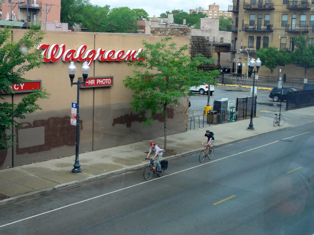
That’s John Edel in the red helmet in front of Walgreens in the ‘Norsman Architect’ photo.
Yes, but WP Newbies have a problem with EVery intersection. (excellent article, Steve.)
It may seem counter-intuitive, but sometimes poorly-designed intersections are actually relatively safe only because everyone instinctively recognizes them as such and so is on heightened awareness.
I’ve read research that supports this. A major problem will arise, though, if a crash occurs that is more extreme (injurious) than it would have been had the intersection been better designed and it was clearer where each road user belongs.
For example, there are no walk signals so it’s unclear when a pedestrian should not start their trip across the street if they would like to make it “on time” before the cross direction turns green.
Yeah — the real problem is with intersections and roads which *appear* safe but actually *aren’t* — “deceptively dangerous” roads. Roads where it looks like there are good sight lines, but actually there are invisible alleys. Stuff like that.
It is really unfortunate that this got pushed back. I bet at least three days a week the southeast bound Milwaukee signal blocked by a loading truck. I would imagine right turning traffic has as hard of a time seeing pedestrians crossing as bikes do anticipating traffic from the right.