Shaun Jacobsen is an Uptown resident working in market research for a French company. He graduated recently from University of Wisconsin-Milwaukee with majors in French and sociology, and a minor in urban planning. He writes in a personal blog, Transitized, about international perspectives on local transportation issues. This article was originally published on Transitized on December 16, 2012.
In December, I was walking down North Avenue (near Clybourn Avenue and Halsted Street) in Lincoln Park. Something I’ve noticed before, not only when walking but also on the rare occasion where I’ve driven, is that North Avenue is a very narrow, fast street with narrow sidewalks:

Narrow sidewalk near storefronts on North Avenue. Credit: Shaun Jacobsen.
There are at least 50 stores/restaurants along/just off of North Avenue. Many of the storefronts are recessed back from the sidewalk (either to create a small plaza or because there is a parking lot). Kudos to the few stores that decided to recess their stores to create a plaza/wider walkway, as the sidewalks are very narrow and the existing street furniture (where it actually exists) doesn’t do much to make pedestrians feel safe from fast-moving traffic on North Avenue.

Two-stage crossing at North Avenue and Clybourn Avenue. Credit: Shaun Jacobsen.
The traffic situation is a mess. Not even because there’s too much of it or a high average daily traffic count, but because there are too many opportunities for cars to exit/enter parking lots/garages along the street. The intersection of diagonal Clybourn Avenue at North Avenue (pictured above) makes crossing Clybourn on the southern end of North difficult.
Riding a bike on North would be difficult and I would probably not attempt it. But North is a perfect street to get from neighborhoods west of the Kennedy Expressway (Wicker Park, Humboldt Park, etc.) to this neighborhood and the Lakefront [trail]. The only other direct way to get there is the #72 CTA bus, which often gets stuck in the traffic, or Division Street (1/2 mile south), which is also full of fast-moving traffic.
How could we make North Avenue more friendly to pedestrians, people on bikes, and those arriving by public transportation?
North Avenue is not proposed to be any sort of bicycle-friendly street in the recently-released Chicago Streets for Cycling 2020 plan. It is an arterial, high-speed street that cuts through at least three neighborhoods with lots of people. What I’m proposing is not part of any existing plan, it would certainly be difficult and costly to implement, but ideas start somewhere, and aren’t always perfect, nor cost-effective, nor publicly appealing the first time around. Take a look anyway:
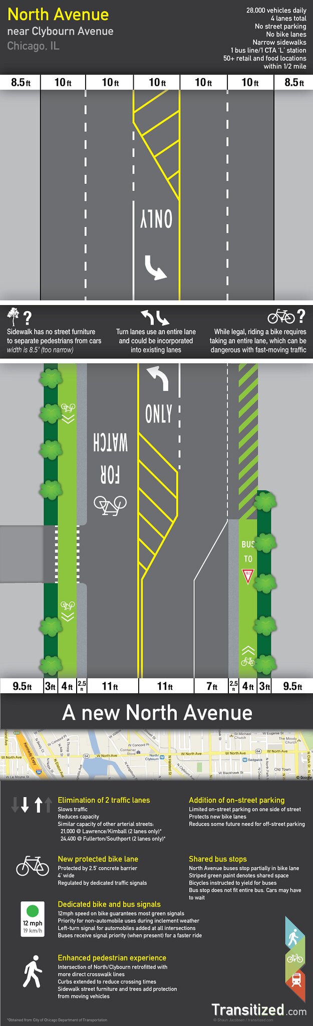 I wanted to take some of the best ideas from other cities and even Chicago neighborhoods, and implement them here:
- Protected bike lanes: In my opinion, these are the single-best tool to get people to feel more comfortable biking in the city, and therefore are the best way to actually get people onto a bike. I don’t believe that buffered bike lanes are any better than the majority of bike lanes, which are just some extra paint. Give people protection and their own signals, and they’ll feel more comfortable and more safe. Even though the City of Chicago does not build protected bike lanes on narrow streets like North Avenue, I implemented this idea.
- Green wave for people on bikes: This is another way to get people more comfortable on a bike. Riding at an easy speed (around 12 mph) is safe and efficient, so timing the signals to get people on bikes going through more green lights at this speed gets them to their destination faster and without having to exert a lot of energy stopping and going at every light. This may not always be possible given the other goals (prioritizing signals for buses), however.
- Shared bus stop: I couldn’t think of a better way to incorporate bus stops in the design with the narrower streets. People on bikes should stop for buses that are unloading/picking up passengers. Right-turning cars should wait for buses and bikes (instructed by a sign) and right-turns on red would be prohibited.
- Prioritize the bus: To keep the buses moving and out of the bike lane, signal prioritization should be in place for CTA buses. Longer greens for approaching buses will keep all traffic flowing better.
- Reduce pedestrian crossing distances: The current intersection of North and Clybourn is large and dangerous. Pedestrians shouldn’t have to cross such wide distances with fast-moving cars whizzing by in all directions. Extending curbs where possible and implementing a direct crossing or pedestrian scramble at intersections like these will improve the pedestrian experience on heavy retail streets like North Avenue.
- Adding street furniture: North Avenue currently has little street furniture. Trees, potted plants, and benches help separate road traffic from pedestrian traffic. There is not currently room for more furniture without reducing either the sidewalk or road width. The road width is sacrificed for the good of non-automotive users: people on foot or on bike.
Many of Chicago’s streets were designed for cars to move quickly. As we see young people buying cars less, riding bikes, walking more, and our neighborhoods relying on the economic diversity of many people coming by way of many different transportation modes, it only makes sense to make our streets more equitable – even if that means reducing the capacity for cars. Having more roads only means more drivers will occupy them: reduce road capacity and you reduce unnecessary trips that can be completed using other transportation modes. Existing portions of east-west arterial streets like Lawrence Avenue and Fullerton Parkway have half the total lanes of North Avenue but still handle more than half the capacity. A reduction in lanes won’t necessarily mean an increase in traffic over the long run. Drivers will adapt.
This idea would work in many neighborhoods, including Lincoln Park nearer Diversey and Clark, which is already heavily developed but still underserved by public transportation and lacking in decent bicycle infrastructure. It’s time we created a more equitable network of streets in our densest neighborhoods, especially those where walkable retail and restaurant options have appeared without the walkable infrastructure to serve them.
I like this a lot. The whole North/Clybourn area is a gigantic mess and planning failure—it really deserved better than to be the glorified strip mall it’s become.
Thanks Beta – I completely agree. I have often said if I had to pick my least favorite intersection in Chicago it would be North/Clybourn. It just really sucks to be there.
North/Clybourn is basically Michigan Ave. 2.0: expensive chain shops and wide traffic lanes with speeding cars.
I like that at least some of the shops face the sidewalk, but the majority of them are fronted by parking lots, which really does prioritize vehicles. Many other stores in the Lincoln Park/Lakeview area have parking lots above, below, or behind shops. Hiding them is better (although the entry and exit points that are on busy sidewalks do create some conflict with drivers).
I love the idea of making this area more pedestrian-friendly. But I think there’s an easier solution that should be pursued first – rezoning. Right now, it’s almost impossible to build the dense, mixed-use towers that this area could support. From what I’ve heard, it took a lot of legal wrangling to get Sono I and II built.
This is a highly-attractive spot to live: great neighborhood, surrounded by retail, and on top of a 24-hour transit stop. There’s no reason we should be seeing suburban-style strip mall development here.
That transit stop just happens to be separated on all sides by 4 lane roads!
This area has so much potential.
The main problem with this plan is that not all the traffic is local for the shops along this strip. In the summer this is the main thoroughfare for suburbanites from the Kennedy to the beach. That traffic that cannot be converted to bicycle/CTA and also needs to be accounted for.
I do agree that the area is pretty terrible no matter the form of transportation and something needs to be done. I wish the CTA would to a better job of adapting to serve new shopping districts such as this and Roosevelt.
If it’s equally terrible for everyone, does that make it a complete street?
I wouldn’t write off that that traffic cannot be converted to other modes. Much like parking + transit is provided for Sox and Cubs attendees, remote parking could be implemented for beach access. The parking lots at many of the beaches fill up. North Avenue’s parking lot can never meet the demand. Even Montrose, which has an abundance of parking, sometimes fills up.
I’ve driven to the North Ave beach once (a long time ago) and there is no parking in the summer. I had to park many blocks away. I can’t imagine that many people are getting to the beach by car – unfortunately the only way to get from the west directly to the beach is the North Ave bus, which is clogged up in traffic when the street is really busy (it’s slow).
Good luck with that. North Avenue is a state route (IL-64) and is thus controlled by IDOT, who tend to facilitate car traffic over all else.
You don’t say…
CMAP says North Avenue is a “strategic regional arterial” route. That means they think it should be lots of lanes and high speed with no parking.
http://www.cmap.illinois.gov/c/document_library/get_file?uuid=91eef6a1-77b4-47b4-bb1d-b5dd3e1c3e80&groupId=20583
That really is unfortunate, because I don’t think any of the streets in this part of the city should be classified that way. The fact that IDOT has jurisdiction is bad enough. In 2013, more people (and planning agencies, especially) should realize that fast traffic can destroy a street or prevent decent development. This strip, as well as Damen/Milwaukee/North, are two exceptions where there is heavy development. The rest of North Ave is pretty depressing, with lots of parking lots and minimal foot traffic.
Its amazing how far I go out of my way to never use North. Which is annoying since I live off it in Wicker Park. As a cyclist, that road is a death trap from the beach out to City limits. As a pedestrian, its also a complete nightmare, but both more so in the area mentioned in this article. Whenever I have to run errands in the area, I’m constantly going a half mile out of my way (Armitage or Division) to come in directly above or below my destination. I will clap my hands in joy if that ever changes, but with any State level DOT, these are typically pretty hard to do.
Have you tried using Cortland? It’s decent good way to cross the highway.
North Avenue between Paulina Avenue and Oakley Avenue is decent. There are rush hour parking controls, though, that widen the street in one direction for a couple of hours.
I don’t disagree, its just the whole “greater six points” area, with so many cars coming and going, is a complete be on the defensive for dooring exercise. Point is, if I can avoid North, I will.
But look at how much less retail activity goes on North Ave compared to Damen or Milwaukee. North has got a whole bunch of “cursed” storefronts that can never hold a tenant for long (all the way from the Kennedy west), I think in large part because it’s such a dismal pedestrian environment. Fullerton (another fast wide street with narrow sidewalks) west of Kedzie is the same story.
I think the rush hour parking controls on North Avenue add to the tenants’ disadvantage as they disallow, for ~4 hours each day* the car parking some of the customers of those tenants need.
* The duration is larger than 4 hours as there’s the time at the beginning end of the two-hour periods where people will not park because they need to park there for a time that would then enter the ban period. For example, the band period starts at 4 PM westbound. If I have to park there for 45 minutes, I must arrive by 3:15 PM to shop there. But I can’t always time my arrival!
But a majority of shoppers in that neighborhood do not arrive by car. The parking controls don’t do a thing for pedestrians who are still stuck on too-narrow paths.
Besides, even if parking availability were the sole factor, then North Avenue west of Western and Fullerton west of Kedzie, where there is parking for days, should still be bustling commercial streets. They’re not, apart from a few pockets. It’s not a coincidence that both corridors declined precipitously after the streetcar lines were dismantled.
It sounds like any attempts at a “green wave” pilot are tabled (at least downtown, according to the Grid’s Dec Mayor’s Bicycle Advisory Council Meeting coverage), but I do love the idea. It would be nice for me to be rewarded with a green wave for cycling 12 mph on my old Schwinn Collegiate to offset my feelings of losing a race as all the speed-demon cyclists fly past me!
That applied only to downtown because the “grid is too tight”.
It’s great to see someone re-imagining this entire area, because it could certainly use it. North Ave from Halsted to the river is the poster child for an Incomplete Street. In addition to the problems Shaun details, I’ll add that the bus stops are mostly just poles in the ground, nothing more.
Thanks for pointing that out – there is just no room for street furniture, and sometimes the queues for the bus stops are crowded enough to impede other foot traffic on the sidewalks. This stretch just feels more dangerous because there is no buffer (like parked cars) to protect pedestrians from the street. One misstep and you could be in the center of a fast road lane.
You don’t consider the 2 foot high curb on North between Sheffield and Halsted a buffer? Some sarcasm there, but some truth too.
I have heard so many times when I have brought up the the subject of North Ave into the discussion I was told ” You can’t do anything on North Ave, that’s a state highway ! ” I am so glad to hear someone proposing something on this street. The reason why this street is so wide is because a trolley used to run down it. The trolley was taken out and it became a four lane highway. It was never originally designed as a a 4 lane street. Let’s bring it back to it’s original design, Public transportation and add in bicycle lanes for modern times.
The Illinois Department of Transportation is currently standing in the way of building protected bike lanes on roads under its jurisdiction, calling for 3 years of data (still looking into this).
I don’t think you need to do a road diet to the extent you’ve proposed to make it pedestrian friendly. Keep four lanes of traffic at 9′ wide, lose the middle turn lane, and allow 8′ wide onstreet parking instead of widening the sidewalks and bike lanes since that’s a better barrier for peds. See O’Bryanville in Cincinnati.