
This sidewalk will be eliminated to make room for a new right-turn lane onto southbound Lake Shore Drive. Photos and captions by Bike Walk Lincoln Park.
Michelle Stenzel, a co-leader of the Bike Walk Lincoln Park neighborhood advocacy group, hits the nail on the head with her analysis of a construction project to rebuild the Fullerton Parkway bridge over the Lincoln Park Lagoon. The project, from the Chicago Department of Transportation (CDOT), widens the street from four lanes to five, reroutes pedestrians on the south side sidewalk over a long path to cross the lagoon, and doesn’t install bikeways to and from the Lakefront Trail. It also replaces a crumbling bridge and improves upon the existing bridge design. The project will begin construction on Monday, March 19, 2012.
What’re the shortcomings? She outlines three problems on the Bike Walk Lincoln Park after attending a presentation Wednesday night. They are:
1. Elimination of the sidewalk on the south side of the bridge
People walking on the south sidewalk from points west toward the lake front trail will be routed onto a curved path down toward the lagoon, then northward under the under pass, then either up a set of stairs or around a looping path upward, then turned around to face east again, and over the bridge, under the Lake Shore Drive underpass, and then onto the lake front trail.
That’s a long walk for what is currently a short trip.
2. Fullerton Parkway will have an additional lane added for car traffic for the intended purpose of easing car traffic on Fullerton.
Adding this right-turn lane is being described as an improvement of safety for pedestrians since there are “fewer points of conflict” with car traffic, but it is being done by simply eliminating the presence of pedestrians.
According to traffic crash data from the Illinois Department of Transportation (IDOT), there have been very few crashes at the right-turn lane’s intersection with the sidewalk and crosswalk, in the six-year period of 2006-2010. There was one crash between an automobile and pedestrian in 2005, one crash between an automobile and a bicyclist in 2007, and one crash between an automobile and a bicyclist in 2008; that makes a total of three crashes. This pales in comparison to the high number of crashes at the Lakefront Trail’s intersections with Montrose (13 crashes within 100 feet), Wilson (14 crashes), and Foster (10 crashes); each is a top 20 crash-frequent intersection for pedestrians and people cycling in Chicago.
[flickr]photo:6983992303[/flickr]
The 3 pedestrian and bicycle crashes within 100 feet of the Fullerton Parkway and Lake Shore Drive on-ramp intersection that will be redesigned to improve safety. I can list 20 other intersections that need their pedestrian safety improved before this one, starting with Madison & Cicero, where there were 36 crashes within 100 feet, from 2005-2010.
[flickr]photo:6837874238[/flickr]
The 13 pedestrian and bicycle crashes within 100 feet of the Lakefront Trail and Montrose Avenue, adjacent to the Lake Shore Drive ramps.
3. Lack of accommodation on the street for people riding a bicycle to and from the Lake Front Trail
Since Fullerton is already scary to ride on, most people on bicycles currently ride on what I always considered a sidewalk, since it’s concrete, and it looks and feels like a sidewalk. When I brought up this issue at the meeting, CDOT staffer and former chief bridge engineer Dan Burke said that it’s actually a mixed use trail once you enter the park east of Lincoln Park West, and bicyclists can and should use the “sidewalk”. Apparently, [westbound] bicyclists are now expected to take the path with its up and down grading and loop de loops.
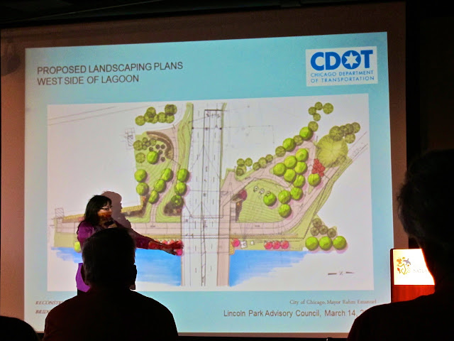
On this drawing, north is to the right. It reflects the deletion of the south sidewalk, and the looping path onto which all east- and west-bound pedestrians and bicyclists will be routed.
What’s the problem? The City of Chicago and the State of Illinois both have complete streets policies (so does Cook County, but they’re not involved here). The policies dictate that all transportation modes and all users of a transportation system (especially the most vulnerable users like children and elderly) are considered in the planning, design, and construction of any transportation infrastructure project. The City’s is merely a policy adopted by the City Council in 2006, but the Illinois’ belongs in state law and took effect July 1, 2007.
Illinois’ complete streets policy mandates bikeways except when the Secretary of Transportation approved an exemption based on “excessive cost or absence of need”. (There are other exemptions, but I don’t believe them relevant to this project.)
The Illinois Department of Transportation is probably involved in this because it has jurisdiction over the on-ramps leading to Lake Shore Drive and this project encompasses those. I’m concerned at how this project, and countless others that don’t pass Complete Streets muster, was able to continue with its severe lack of consideration for two transportation modes. While you could argue that some conditions for pedestrians are being improved, mobility is being reduced by eliminating an entire sidewalk and elongating the travel distance for pedestrians who started their trip on the south side of Fullerton Parkway.
Excusing the design of this project’s shortcomings by saying planning and design work started before the current pro-sustainable transportation administration, or the adoption of complete streets policies, ignores the needs and demands of people living here today and now.
Read our other articles about the lack of attention paid to complete streets.
Other discussions on this topic
- EveryBlock
- BikeWalk Lincoln Park (the originator)
Fullerton just seems cursed for cyclists and pedestrians.
And, speaking of pedestrian crosswalks that get no respect, the one on the north side of Fullerton (LSD off ramp headed SB) is the WORST, hands down, in the entire City.
Hundreds of times I have had a driver looking anywhere but in front of them as they almost ran me over. Apparently there is something confusing about that fat white stripe, because 9 out of 10 drivers blow right over it and don’t even begin to stop until they’re already violating the crosswalk. Seriously, I bet you could film 50 traffic violations in 15 minutes during rush hour there.
As far as crashes between automobiles and pedestrians go, though, the intersections around Fullerton and Lake Shore Drive are safe.
I think there might be another issue, on the east side of LSD, there’s a crosswalk signal on the southbound side only (the offramp from NB LSD), not on the north side (onramp to NB LSD). If they’re expecting all peds to be on the north side of the street later, are they changing that too, or are they just going to forget about it?
According to this image, yes, that will change. http://4.bp.blogspot.com/–TU487GaxIM/T2FZApDQ7EI/AAAAAAAAA4E/kglpZUcf1ss/s640/IMG_4989+2-BikeWalkLincolnPark.JPG
At that image size, I’ll have to take your word for it, since the fine detail doesn’t come across well.
Local pedestrians need to leave home with a pocketful of roofing nails, and return home empty. When drivers who use the road get tired of flat tires, they’ll find alternate routes.
So thats how they figured out how to knock out an entire grove of 100 year old trees and remove access to one of the best views in the city. Way to go CDOT
And why exactly is a right turn only lane needed anyways? Simply put in a pedestrian crosswalk light that allows for drivers to turn uninterrupted en mass, but still allows for a safe pedestrian crossing. There, I just saved the city millions of dollars, a few dozen 100 year old trees, one of the best views in the city and didnt even piss a single Lincoln Parker.
I live near that Montrose / LSD / bike path spot. I’m guessing most of those accidents are drivers speeding eastbound towards the lake. They come out from under LSD and it looks like a long clear stretch of road with no cross traffic. Drivers accelerate thinking there is no cross traffic and what has to be about a mile of clear curving wide park road ahead. In a car your eyes lift to the horizon and the lake. Fun! A day at the park!
Only there is cross traffic about 50 yards away in the form of the bike path. Ka-RUNCH!
That’s often been my experience, although a fair number of accidents and near misses come from drivers speeding west and hoping for a quick right hook onto the LSD ramp.
It is a uniquely bad intersection. If road width and open space leads to speeding then that stretch of Montrose east of LSD in the park is a prime speeding zone. And I think there are visibility issues with the bike path – you have some awareness of the ramps to LSD on your bike but very little awareness of the cross traffic coming from Montrose. It would be a good spot for those orange signs in the middle of the street like they have in Evanston and Oak Park.
I think it would also be a good spot for a raised crosswalk. That is, the Lakefront Trail would never dip down to the level of the street. There would, in effect, be no curb. Drivers would “climb” a small slope to cross the Lakefront Trail. This feature “drives home” the point that they are entering someone else’s “protected” space.
Yes, I love this idea, raising it and making it a different color as well. Highly visible, and emphasizes that it’s an extension of the multi-use trail, and not actually part of the street.
Here’s a post I just wrote about raised crosswalks. I spotted one in Forest Park last month.
http://www.stevencanplan.com/the-first-raised-crosswalk-ive-seen-in-illinois/
There are stop signs at all of those Lakefront Trail/Montrose Beach intersections.
Another oddity at these intersections is that Lakefront Trail users don’t have to stop here, at all, while only cross traffic does. This just “doesn’t seem right” to some and they slow down and some stop.
Exactly. That crosswalk signal aligned with the soon-to-disappear sidewalk on the south side of the bridge is exactly why I’ve used that sidewalk (in times of heavy traffic) to go from Stockton to the lakefront, as hundreds of peds and cyclists do on any given day.
The sidewalk on the north side is nowhere near wide enough to handle even the ped traffic, and I don’t see everyone willingly going along like sheeple with the “they can just use the underpass” idea.
We’re facing an equally bad reconfiguration at 95th and Western, in conjunction with the soon-to-be-redeveloped Evergreen Plaza AND the planned new mega-retail-mess at 91st and Western, just 1/2 mile away – wider intersections and a lot more traffic. This is NOT a good trend.
I maintain that any true Complete Street should be outfitted with a swimming lane in each direction. If Complete Streets are “designed and operated to enable safe access for all users”, then my preference to commute via swimming should be accomodated.
I don’t think any transportation planners yet recognize swimming, canoeing, or kayaking as commute modes.
Wait until I get my kayak and start pulling it by bike down Belmont to the river launch. Whether it’s crazy (per the wife) or mad genius (my take) remains to be seen….
All things considered, the cost to taxpayers would be lower than supporting automobile transit. Good job!
A conflict I haven’t seen discussed is what happens with the existing south sidewalk under LSD? How do they plan to close this path under the LSD viaduct and it’s connection to the lakefront? Safety issues abound since too many bicyclists and pedestrians will attempt dangerous crossings if they think they will save a few seconds.
Take a look at the very first picture in Michelle Stenzel’s article (linked near the top of this article).
From that picture it looks like the south side sidewalk under LSD will be removed. The sidewalk on the north side under LSD will be widened (to 20 feet?). In other words, the four traffic lanes will be shifted south and the sidewalks will be consolidated on the northside of the underpass.
There will no longer be a sidewalk on the southside of Fullerton from Cannon Drive on the west to the Lakefront on the east. I think that sends a pretty clear signal to pedestrians not to walk there? But I agree that for cyclists going east on Fullerton, the situation may not be as clear.
I like the design. Perfect? No. A good compromise? Yes.
– The current underpass is one of the worst I know in the city. Replacing it with a nice, new one with an even surface is a good start.
– By re-routing the pedestrian and bicyclist to the north side of Fullerton, they will now cross traffic entering and leaving LSD on the lower use ramps (I have no scientific data here, but my own personal observation shows that more traffic exits NB LSD then enters NB LSD at Fullerton, same goes for SB traffic. If I’m wrong about that, I’ll gladly revise my viewpoint)
– There are really four intersections. Three intersections where traffic can move into the intersection and interfere with pedestrian and cyclists (NB off ramp, SB off ramp, SB on ramp) and one where this cannot happen (NB on ramp). By removing two of these intersections (SB on ramp, NB off ramp), you remove two potential causes of conflicts.
– Guard rails can be very visual indicators as to where to walk/cycle, so you can guide peds/bicyclists to use the underpass.
The one drawback that I see is that pedestrians will have to walk further to get to the lake.
How it ultimately will work will have a lot do to with how they manage traffic lights, specifically at the intersections of NB on ramp on SB off ramp. Will they give priority to pedestrian or to cars?
YOU SOUND LIKE LUCY