CDOT’s Gabe Klein announces viaduct repaving project

At a press conference in Englewood Friday, CDOT Commissioner Gabe Klein announced a $4.1 million project to repave roads under 14 viaducts in 13 different wards across the city (average cost $250,000 per viaduct).

[flickr]photo:7177055156[/flickr]

He explained that seeking federal funding for this project would free up more locally generated funding for neighborhood street repair and repaving projects.  The entire project is federally funded under the American Recovery and Reinvestment Act (ARRA).

[flickr]photo:7177054668[/flickr]

Crews are doing complete road reconstruction on approximately 4,500 linear feet of roadway at the following locations (see map below): Continue reading CDOT’s Gabe Klein announces viaduct repaving project
A stealth route along the South Branch of the Chicago River

[flickr]photo:7127710589[/flickr]

View from the hill located in the Brownlands.

[This piece also appeared in “Checkerboard City”, John’s weekly transportation column in Newcity magazine, which hits the streets on Wednesday evenings.]

A local ordinance requires that all new developments along the Chicago River include public access to the waterfront, so eventually there could be a network of riverwalks to rival the Lakefront Trail. But for now it takes a little detective work to navigate the waterway by bicycle. I’ve researched a few “stealth routes” along the North Branch, connecting bits and pieces of riverfront path with quiet side streets — you can read about them here. Last week I scouted out a fascinating route along the South Branch from the Loop to Bridgeport, but I should warn you that it isn’t completely legal. Here’s a Google map of the route.
Continue reading A stealth route along the South Branch of the Chicago River

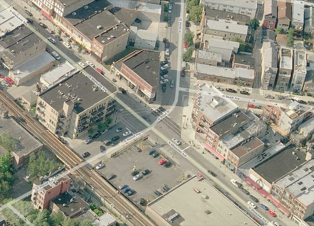
Confusing intersection of Milwaukee-Wood-Wolcott to be redesigned and reconstructed in Spring 2013 (was September)

Update September 7, 2012: From the Wicker Park-Bucktown SSA, we get news that this project has been pushed back to spring 2013. It seems IDOT is responsible for this delay. 

The skewed intersection of Milwaukee Avenue, Wood Street, and Wolcott Avenue in Wicker Park will be redesigned and reconstructed this year as part of a project to upgrade the signals. The original project only called for upgrading the traffic signals, which are decades old and very hard to see. Their timing is also awkward, providing no “all red” phase between the red phase of one direction and the following green phase of the cross direction. Construction should begin in September, according to the 1st Ward office.

Confusion is compounded with the addition of a rare slip lane on Wood Street at Milwaukee Avenue, which is created by a small island of concrete that only holds a light signal pole for southbound traffic. More often, islands are used to help protect pedestrians from traffic.

Bird's eye view of Milwaukee Wood Wolcott

View the intersection in a larger map on Bing Maps.

Continue reading Confusing intersection of Milwaukee-Wood-Wolcott to be redesigned and reconstructed in Spring 2013 (was September)

Fatality Tracker: Woman dies after being hit by Rock Island Metra train

[flickr]photo:3996816091[/flickr]

2012 fatality stats*:
Pedestrian: 3
Pedalcyclist: 0
Transit: 0

Updated March 16, 2012: I’ve recategorized this as a pedestrian death, and not a transit death. Also changed the deceased’s home location and corrected the Street View.

Gardenia Boyer, 23, from the Brainerd neighborhood, was struck and killed by an empty Metra train at 95th Street and Vincennes Avenue on the Rock Island branch going south towards Blue Island, Illinois. It happened on Wednesday morning, around 7 AM. She was walking east on 95th Street. There are two tracks here. Walking on 95th Street never seems like a good idea: the first fatality tracker post was about two people killed while crossing 95th Street. She had two daughters.  Continue reading Fatality Tracker: Woman dies after being hit by Rock Island Metra train

CDOT proposes road diets, protected bike lanes for King, 31st and 55th

[flickr]photo:6940279875[/flickr]

CDOT’s Mike Amsden and 4th Ward Alderman Will Burns

I’m always happy to pay a visit to my old stomping ground of Hyde Park-Kenwood. So Monday afternoon I took advantage of a nice southbound wind and pedaled down the lakefront to Kenwood Academy for a 4th Ward community meeting hosted by Alderman Will Burns. At the assembly Chicago Department of Transportation (CDOT) bike planner Mike Amsden gave a presentation about the CDOT’s plans to install protected bike lanes and buffered bike lanes on the Near South Side. The new facilities would be part of the city’s Streets for Cycling plan to install 100 miles of protected lanes and some 150 miles of other innovative bikeways over the next few years.

Here’s a map of the proposed locations in or near the 4th Ward. As Amsden outlined at the meeting, these streets would be undergoing “road diets,” removing and/or narrowing car travel lanes to make room for the new bike lanes. Additional benefits would include discouraging speeding and other reckless driving behavior, as well as reduced crossing distances for pedestrians. Continue reading CDOT proposes road diets, protected bike lanes for King, 31st and 55th

Streets for Cycling concerns: What about Logan and Western?

[flickr]photo:6833972893[/flickr]

LOOK!

You ask, I answer. Or, really, the Chicago Crash Browser (super beta draft version) and automobile collision data from the Illinois Department of Transportation answers. James Baum asked on The Chainlink:

From an engineering point of view I am very interested in how they plan on “fixing” the mess that is the Logan Blvd underpass. I feel that this area definitely fits under the “do the easy stuff first and the hard stuff last”  category on the hard side. The intersection is dangerous enough for motor vehicles and I’d like to see some crash statistics for autos there.

I agree that cycling through here is a problem; it seems that getting through here regardless of mode is a problem, though. The Moving Design group of design activists, of which I took part, created a large visual to raise awareness (“LOOK!”), using stencils, hair spray, and a fire extinguisher.  Here are all the pedestrian and “pedalcyclist” crashes. Notice how few pedestrian crashes there are within 250 feet of the center where Logan Boulevard and Western Avenue meet. That might be because few people actually walk here, avoiding it like the plague our streets are: Continue reading Streets for Cycling concerns: What about Logan and Western?