Illinois traffic fatalities are up this year: What to do about it?

[flickr]photo:7213242382[/flickr]

Can you find anything “bad” or “could use improvement” about the design of this intersection between Ogden Avenue and an on-ramp to northbound Kennedy Expressway? There are clues in Notes below. 

Two weeks ago, a commenter asked about the LED signs on Illinois highways. This article from the Chicago Tribune tells what they’re showing:

When travel times and Amber alerts aren’t being shown on electronic message boards, a running tally of traffic deaths in Illinois is often displayed along highways across the state to remind motorists about the consequences of dangerous driving.

What are the other factors at play in this increase? Does dangerous design have a role? Or economic factors?

On Saturday, August 11, I went with a friend on the CTA Blue Line to Forest Park with our bikes; we got on the Illinois Prairie Path just a few hundred feet away from the train terminal, inside a cemetery. The bike ride was a reminder to me of the persistent road and trail design inconsistencies, within cities, within states, and across the country. I went on a road trip to Richmond, Virginia, during which I drove on the highways and local roads of 5 states. It seemed to me that the Manual of Uniform Traffic Control Devices (MUTCD), a federal document that every road, path, and bike lane builder in the country must follow (or obtain exemptions from), was lost or deleted. Continue reading Illinois traffic fatalities are up this year: What to do about it?
Bicycle crashes: A presentation at the Transport Chicago conference

[flickr]photo:7391617984[/flickr]

I assisted Nabil Nazha in gathering data and developing a methodology for the geographic analysis of bicycle crashes at intersections needed to complete his master’s thesis from the University of Illinois at Chicago’s College of Urban Planning and Public Affairs (CUPPA). I graduated from CUPPA in 2010. We submitted his paper to the Transport Chicago conference and it was accepted; see Session 1 – A Safety Dance. He was out of the country at the time of the conference so I gave this presentation alone. 

[slide 1 – intro]

From 2007 to 2010 there were 6,705 bicyclists involved in 6,664 crashes involving at least one bicycle and one automobile. A majority of bicyclists received injuries and 20 bicyclists died . Bicycle crashes at intersections are the topic of the paper, Safe Cycling in Chicago. Continue reading Bicycle crashes: A presentation at the Transport Chicago conference

Video captures “Milwaukee morning madness” as cyclists pedal towards Kinzie and Desplaines Streets

[vimeo]43679233[/vimeo]

Brandon Gobel sent us this video showing dozens – I count 27 – of people bicycling southeast on Milwaukee Avenue towards the five-way intersection with Kinzie Street and Desplaines Street. There were 13 motorized vehicles in the same signal cycle.

You’ll notice about half are changing lanes from the conventional curbside bike lane to the single travel lane so they can merge to the bike left-turn lane ahead.

[flickr]photo:6048794548[/flickr]

The view from the opposite direction, looking southeast at the intersection of Kinzie Street, Desplaines Street, and Milwaukee Avenue. 

Unfortunately, because of signal timings at the intersection they just left (Hubbard/Milwaukee) uncoordinated with their destination intersection, the first in the group won’t be rewarded with a green light for their tricky uphill lane change maneuver, and will need to stop at the red light, while those in the back of this group will likely get a slim chance at moving through a green light (the green light is only 12 seconds long).

I’ve heard from several people who cycle here, Gobel included, that changing lanes from the curbside bike lane in a dark viaduct to the travel lane in order to reach the bike left-turn lane ahead can be very stressful.

Another issue with the light, but not related to this video, is that the light cycle for people who want to cycle from Milwaukee to Kinzie (making a slight left to go eastbound) is designed such that if you enter the intersection at the end of the green phase, you will be in the intersection for the entire yellow phase, part of the red phase, and then the beginning of green phase for the cross direction. I explored this – long intersections – on my blog, Steven Can Plan.

Confusing intersection of Milwaukee-Wood-Wolcott to be redesigned and reconstructed in Spring 2013 (was September)

Update September 7, 2012: From the Wicker Park-Bucktown SSA, we get news that this project has been pushed back to spring 2013. It seems IDOT is responsible for this delay. 

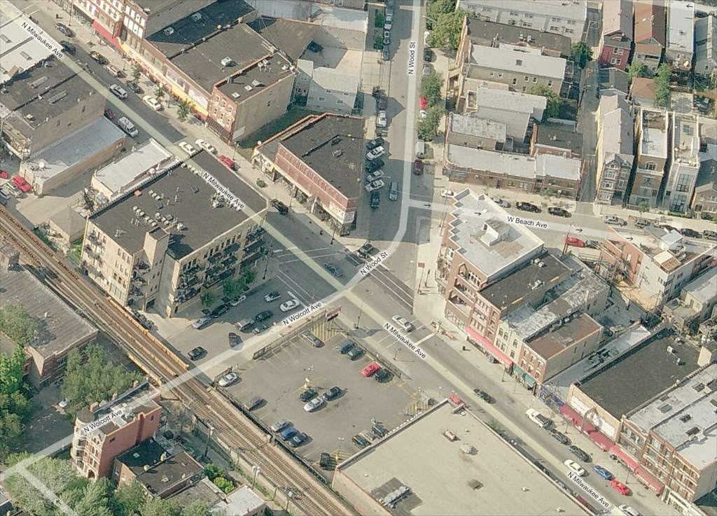
The skewed intersection of Milwaukee Avenue, Wood Street, and Wolcott Avenue in Wicker Park will be redesigned and reconstructed this year as part of a project to upgrade the signals. The original project only called for upgrading the traffic signals, which are decades old and very hard to see. Their timing is also awkward, providing no “all red” phase between the red phase of one direction and the following green phase of the cross direction. Construction should begin in September, according to the 1st Ward office.

Confusion is compounded with the addition of a rare slip lane on Wood Street at Milwaukee Avenue, which is created by a small island of concrete that only holds a light signal pole for southbound traffic. More often, islands are used to help protect pedestrians from traffic.

Bird's eye view of Milwaukee Wood Wolcott

View the intersection in a larger map on Bing Maps.

Continue reading Confusing intersection of Milwaukee-Wood-Wolcott to be redesigned and reconstructed in Spring 2013 (was September)

Can I just cross the street safely for a burger?

[flickr]photo:2659296304[/flickr]

Two guys trying to cross Belmont Avenue towards Kuma’s Corner in 2008. 

My mom, sister, and I were walking to Kuma’s Corner in Avondale tonight (2900 W Belmont Ave). We were starting to cross Belmont Avenue along Francisco Avenue. Eastbound traffic was backed up at the Elston Avenue/California Avenue light so we easily slipped through stopped traffic. Then we looked to the east at fast moving westbound traffic.

Westbound Belmont Avenue has two lanes at this time of day because of rush hour parking controls (RHPC). You probably know what this is but never knew what it’s called. It’s when you can’t park a car on one side of the street during a morning or afternoon two-hour stretch, and you can’t park on the opposite side of the street during the opposite period. It’s to facilitate faster moving traffic and I believe to relieve congestion. Whether it does that is a good question.

Anyway, there were two lanes of fast moving traffic and there were no gaps so we couldn’t cross. Don’t pedestrians have the right of way when crossing streets? Or do they need permission? I understatedly mentioned something about this to my mother, saying “The law requires that drivers stop for people in crosswalks”.

My mother took this as a cue to throw up her hands in disgust and shout, “Can we cross? Let’s go!”

I don’t know if the two drivers in the two lanes heard her, but they obviously saw her gesture and stopped their vehicles. I told her, “No one does that”, referring to the gesture and shout.

Maybe that’s the key to demanding our right to safely cross.

Right after this happened, I tweeted, “@ChicagoDOT what are you doing to increase compliance w/ ‘stop for peds in crosswalk’ law? Does the CPD pull over drivers anymore? #walkCHI”

Will 47th Ward residents learn to love the bike boulevard?

[flickr]photo:6958139237[/flickr]

47th Ward staffer Bill Higgins

A few weeks ago I contacted Mike Amsden, lead planner for the Chicago Department of Transportation’s Streets for Cycling initiative, to ask why CDOT chose Berteau Avenue (4200 N.), from Lincoln to Clark, to be the city’s first “neighborhood greenway” (AKA bike boulevard.) One of the main reasons he mentioned is that the project lies entirely within one ward, the 47th, and there’s enthusiastic support from local alderman Ameya Pawar. Amsden also told me he’s also gotten positive feedback from folks along Berteau who want to see cut-through traffic reduced. “We’ve heard from a few nearby residents who are really excited about it,” he said. Here’s a map of the location.

Last week at a block club meeting about the proposed greenway at a Ravenswood church, I learned firsthand how important it is that the project is slated for only a short stretch of roadway (.9 miles) and has strong aldermanic backing, because it’s turning out to be more controversial than I expected. There were over 50 people in attendance and many of the attendees said they’re afraid that the project will create chaos for drivers.

Continue reading Will 47th Ward residents learn to love the bike boulevard?